Conservation Commission
New London, New Hampshire 03257
Trails
Knights Hill Nature Park Trails
| Trail Number: | 12 | Trail Length: | 3 Miles |
| Difficulty: | Easy to Moderate | Trailhead GPS: | |
| Trail Adopter: |
Trail Description
A
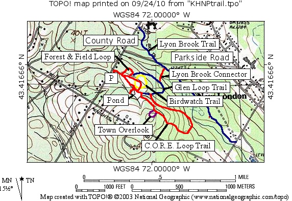
map is available here and at the entrance kiosk that provides a
larger map and a description of the nature trail. Markers
identify trees, wildflowers and ferns along the self-guiding
nature trail. In the summer, naturalist programs are frequently
made available. The
Knights Hill Nature Park Trail System provides public
access to lands owned by the New London Outing Club
(NLOC) and protected by New London Conservation Commission
conservation easements. Parking is available in a parking area
off County Road (P). Five interconnected trails are in the
nature park plus a connector link to the Lyon Brook Trail. The
Forest and Field Loop Trail is a nature trail marked with orange
circular blazes. The Glen Loop Trail is a nature trail marked
with blue circular blazes (in blue on the map). The C.O.R.E.
Loop Trail is a forest trail marked with red circular blazes (in
red on the map). The "Town Overlook Trail" (no views possible)
is a forest trail marked with two red circular blazes, one above
the other, (in purple on the map). The Birdwatch Trail is a
nature trail marked with yellow circular blazes (in yellow on
the map). The Lyon Brook Connector Trail leaves the Glen Loop
Trail at a low point along the trail.
- See Map Below or
Return to Main Trails Page.
Trail Map

Elevation Information
Not available
Photos
C.O.R.E. Loop Trail - Photo by R. Anderson