
Conservation Commission
New London, New Hampshire 03257
Easements
Conservation Easement Overview
Conservation easements serve many purposes and are sold or donated by landowners to meet many objectives. Some of the major landowner objectives include:
- Preservation of natural resource values for future generations;
- Protection and/or improvement of water quality;
- Protection and/or improvement of wildlife habitat;.
- Protection and maintenance of scenic vistas;
- Protection of sustainable land uses such as agriculture or forestry;
- Protection of designated public uses, or;
- Achieving certain estate planning and/or tax objectives.
Benefits and Contacts
Conservation easements typically restrict subdivision and other types of real estate development. Easements do not make the land public land and may or may not confer public access rights. The value of an easement is the appraised difference in market value of the land with and without development restrictions reflected in the easement. This conservation easement is donated, sold, or partially donated to an easement holder such as a Town or Land Trust. The land continues to be owned by the landowner, the landowner is likely to enjoy some tax benefits, and the easement holder assumes responsibilities associated with monitoring the terms of the conservation easement. Additional information about the possibility and benefits of conservation easements may be obtained by contacting any member of the Conservation Commission or by exploring the links to the right.
Easement Monitoring
An easement holder is responsible for monitoring that the terms of a conservation easement are being met. This is accomplished by periodic monitoring and the completion of a report describing the monitoring activity and any violations noted and intended corrective action. In most situations, there is a primary easement holder and a backup. Monitoring may be performed by both. The Conservation Commission routinely monitors many of the easement parcels in New London.
Conservation Land Map
# |
Easement Identifier |
Public Access |
Protects |
Date Recorded |
1 |
Clough - Berger #1, LCIP 120-01 |
Forestland |
12/9/1991 |
|
2 |
Clough # 2, LCIP 120-03 |
None |
Agriculture |
3/24/1989 |
3 |
Clough #3 |
Great Brook |
3/24/1989 |
|
4 |
C.O.R.E. #4 |
Forestland |
2/26/1993 |
|
5 |
Fenwood #5 |
None |
Cricenti Bog |
4/19/1995 |
6 |
Kidder-Cleveland #6, LCIP 120-02 |
Wetland |
12/9/1991 |
|
7 |
Knights Hill Nature Park #7 |
Open land |
12/5/2001 |
|
8 |
Pelfor #8 |
None |
Wetland |
4/3/1995 |
9 |
Pelfor #9 |
Lyon Brook |
4/3/1995 |
|
10 |
Trussell Ridge #10 |
Lyon Brook |
7/24/1992 |
|
11 |
Evergreen Point #11 |
None |
Shorefront |
3/28/2006 |
12 |
Cordingley Preserve #12 |
Forestland |
11/14/2007 |
The map below was obtained from the GRANIT web site. A link is listed below.
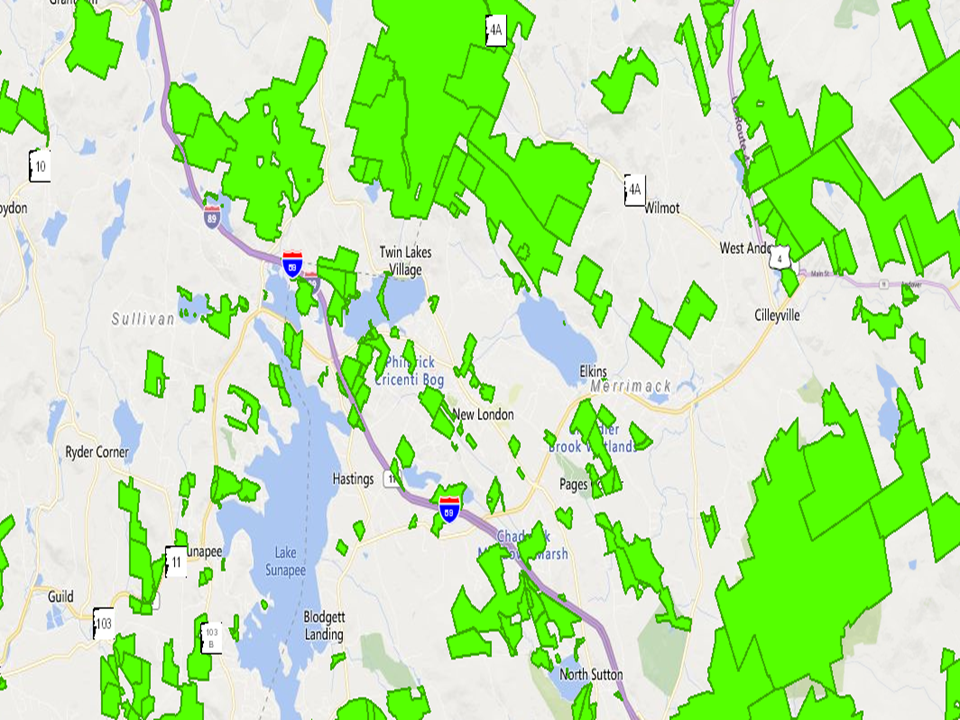
Map
of New London from the NH Conservation Land Viewer. See:
GRANIT.
Note that many of the conservation easements shown in green on this map do not provide for public access.
The numbers on the map below give an approximate location of the properties listed above.

New London Conservation Land.

Typical Conservation Easement Boundary Marker