
Conservation Commission
New London, New Hampshire 03257
Trails
Pleasant Lake High Trail
| Trail Number: | 23 | Trail Length: | 2.7 Miles (one way) |
| Difficulty: | Moderate | Trailhead GPS: | |
| Trail Adopter: |
Trail Description
The Pleasant Lake High Trail (in
red on the map) starts at Whitney
Brook Road along with the
Cook Interpretive Loop Trail. The trail ascends following
along several of the flag marked trails on the Cook property (in
blue on the map). It is now blazed
with a combination of an orange trapezoid and a green circles.
Shortly after passing over the mountain view point marked 17,
the High Trail branches to the left from the
Cook Interpretive Loop Trail, (flagged with pink).
The Pleasant Lake High Trail then ascends
about 90 feet, then descends 170 feet to Deming Pond. The trail
then ascends 480 feet in 0.7 miles to its highest point near the
New London - Wilmot town line. It follows along the town line
descending 200 feet in 0.9 miles to the
Webb Forest Interpretive Trail just below the intersection
with the
Wolf Tree Trail (SRKG) at the
New London - Wilmot town line. The trail, indicated in
red on the map, is 2.7 miles long.
This trail, when combined with the
Langenau Forest Spur Trail, provide a one-way hike of 3.8
miles between parking areas with a net vertical rise of nearly
500 feet. The elevation profile for Pleasant Lake High Trail
starts at Whitney Brook Road and provides the mileage to the
intersection with the
Webb Forest Interpretive Trail.
- See Map Below or
Return to Main Trails Page.
Trail Map

Elevation Information

Photos

Intersection to Pleasant Lake High Trail
Photo by Bob Crane

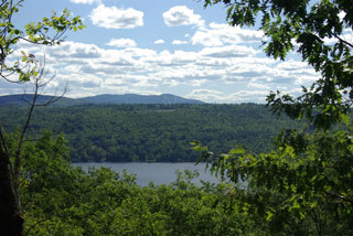
View of Pleasant Lake from High Trail
Photo by Bob Crane
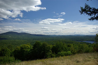
View of Mt. Kearsarge from High Trail
Photo by Peter Brodeur
View of Pleasant Lake from High Trail
Photo by Peter Brodeur